![]()
Open-Source Seismic Hazard Analysis (OpenSHA)
Geospatial File Formats
OpenSHA stores geospatial data in GeoJSON, which is specified in RFC 7946. OpenSHA code for (de)serializing GeoJSON can be found in the org.opensha.commons.geo.json package.
Important note on depths/elevations: OpenSHA stores depth data in km, positive down. For example, a value of 3.0 in the third column of a coordinate array indicates that the given point is 3 km below the local surface. This differs from the GeoJSON specification, but is in-line with the USGS Event Web Service and general treatment of 3D location data in OpenSHA and other PSHA codes. You can load a file in code that uses a different depth standard with the buildGson(DepthSerializationType) method of FeatureCollection.
Download a PDF of this documentation here
Table of Contents
Fault Data
Fault data are stored as GeoJSON Feature objects, and a collection of faults (e.g., a fault model or fault subsection list) are stored in a FeatureCollection. See GeoJSONFaultSection for the OpenSHA implementation of this format.
Fault data requirements
At a minimum, a GeoJSON fault must contain the 3 following items:
1. Fault Trace
The fault trace must be present in the geometry object in the form of a LineString or MultiLineString. If a MultiLineString is encountered and it contains a single LineString (GIS softwares may output single lines in this format), it is supported. If a MultiLineString is encountered and it contains two LineStrings, then the second trace is treated as a lower trace; that lower trace must be below the upper trace (it must explicitly specify depths in the coordinates array), and must be in the same general direction as the upper trace.
Example fault trace as a LineString with 2 points:
      "geometry": {
        "type": "LineString",
        "coordinates": [
          [ -117.74953000000001, 35.74054 ],
          [ -117.76365068593667, 35.81037829696144 ]
        ]
      }
Example upper and lower fault traces as a MultiLineString, each with explicitly stated depths in the coordinates array:
      "geometry": {
        "type": "MultiLineString",
        "coordinates": [
          [
            [ -117.74953000000001, 35.74054, 0.0 ],
            [ -117.76365068593667, 35.81037829696144, 0.0 ]
          ],
          [
            [ -117.74953000000001, 35.74054, 10.0 ],
            [ -117.76365068593667, 35.81037829696144, 10.0 ]
          ]
        ]
      }
2. Required properties
The following properties are required:
| Name | JSON Type | Description |
|---|---|---|
| DipDeg | Number | Dip of the fault in decimal degrees, following the right hand rule. See the glossary for more information. Note: this can be omitted for dipping faults if a lower fault trace is supplied. |
| LowDepth | Number | Lower depth of the fault in kilometers. See simple fault for more information. Note: this can be omitted for dipping faults if a lower fault trace is supplied. |
| Rake | Number | Rake of the fault in decimal degrees, see the glossary for more information. |
| UpDepth | Number | Upper depth of the fault in kilometers, not including any aseismicity. See simple fault for more information. Note: this can be omitted for dipping faults if a lower fault trace is supplied. |
3. Unique ID
A unique non-negative integer ID is required for each fault section. This can be specified either as the id field of the Feature itself (must be an integer), or via the optional FaultID property. If both exist, the id field of the feature takes precedence.
Fault data optional extensions
The following optional properties will be parsed by OpenSHA (other properties may be present and will be ignored):
| Name | JSON Type | Description | Default Value |
|---|---|---|---|
AseismicSlipFactor |
Number | Fraction (value in the range [0,1)) of the fault area that is aseismic, typically applied by increasing the upper depth of the fault such that the area is reduced by this fraction. |
0.0 |
Connector |
Boolean | Boolean indicating that this fault is a Connector (currently unused). | (none) |
CouplingCoeff |
Number | Fraction (value in the range [0,1]) of the slip rate of this fault that is released seismically. |
1.0 |
DipDir |
Number | Dip direction of this fault, see the glossary for more information. | Average trace strike direction + 90 degrees |
DateLastEvent |
Number | Date of the last event that ruptured this fault, used in time-dependent forecasts, expressed in epoch milliseconds. | (none) |
FaultID |
Number | Integer ID of this fault. Must supply either this or the Feature’s id field. |
(none) |
FaultName |
String | Name of this fault. | (none) |
ParentID |
Number | Integer ID of the parent to this fault. This is typically used when subdividing a fault into subsections, and will point to the ID of the original fault section. | (none) |
ParentName |
String | Name of the parent to this fault. This is typically used when subdividing a fault into subsections, and will give the name of the original fault section. | (none) |
PrimState |
String | 2 letter abbreviation of the primarily associated US state for this fault, if it exists. | (none) |
SecState |
String | 2 letter abbreviation of the secondary associated US state for this fault, if it exists. | (none) |
SlipLastEvent |
Number | Slip in meters of the last event that ruptured this fault. | (none) |
SlipRate |
Number | Average long-term on-plane slip rate of this fault in mm/yr. | (none) |
SlipRateStdDev |
Number | Standard deviation of the average long-term slip rate of this fault in mm/yr. | (none) |
SubSectIndex |
Number | Subsection index, 0-based, for a subsectioned fault. The first subsection with the same {@link #PARENT_ID} should be 0, then 1, etc. | (none) |
SubSectIndexAlong |
Number | Along-strike subsection (column) index (0-based) for faults that have subsections both in the along-strike and down-dip directions. An index of 0 means the first subsection in the along-strike direction. | (none) |
SubSectIndexDown |
Number | Down-dip subsection (row) index (0-based) for faults that have subsections both in the along-strike and down-dip directions. An index of 0 means that this subsection is in the uppermost row of the original fault. | (none) |
You can optionally supply a polygon geometry that this fault represents. In this case, the geometry object must be a GeometryCollection that contains both a fault trace (as either a LineString or MultiLineString) and a polygon as either a Polygon or MultiPolygon. For example:
      "geometry": {
        "type": "GeometryCollection",
        "geometries": [
          {
            "type": "LineString",
            "coordinates": [
              [ -117.76365068593667, 35.81037829696144 ],
              [ -117.76492000000002, 35.81665 ],
              [ -117.7758769984411, 35.880450900949334 ]
            ]
          },
          {
            "type": "Polygon",
            "coordinates": [
              [
                [ -117.73341200000002, 36.16374 ],
                [ -117.75440599999999, 36.158123 ],
                [ -117.76325900000002, 36.159714 ],
                [ -117.77182599999999, 36.112068 ],
                [ -117.779052, 36.092946 ],
                [ -117.73341200000002, 36.16374 ]
              ]
            ]
          }
        ]
      }
Note on fault traces for buried, dipping faults
The notion of a fault trace is complicated for buried dipping faults (i.e., those with dip < 90 and upper seismogenic depth > 0). In OpenSHA, we typically assume this simple fault geometry where a rupture surface is defined by the down-dip projection of the fault trace (shown in red at the earth’s surface in the schematic below):
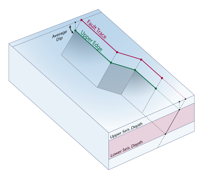
Modelers may wish, instead, to specify the upper edge of the (buried) surface (shown in green in the schematic above) rather than the up-dip extension at the earth’s surface (shown in red). To accommodate this, we adopt the following convention when reading fault section data from GeoJSON:
If trace locations are specified without depths in the GeoJSON file, e.g.,:
"coordinates": [ [ -120.7585, 36.79945 ], [ -120.70175, 36.71373 ], [ -120.64514, 36.62798 ] ]
…then the trace is assumed to be an upper edge and the depths are set to the upper seismogenic depth. So, for example, if the “UpDepth” property (upper seismogenic depth) is set to 5 km, then the above supplied trace would be interpreted as:
"coordinates": [ [ -120.7585, 36.79945, 5.0 ], [ -120.70175, 36.71373, 5.0 ], [ -120.64514, 36.62798, 5.0 ] ]
If, instead, the locations are specified with depths, e.g.,:
"coordinates": [ [ -120.7585, 36.79945, 0.0 ], [ -120.70175, 36.71373, 0.0 ], [ -120.64514, 36.62798, 0.0 ] ]
Or another example, this time with non-zero depths:
"coordinates": [ [ -120.7585, 36.79945, 3.0 ], [ -120.70175, 36.71373, 3.0 ], [ -120.64514, 36.62798, 3.0 ] ]
…then the trace will be placed at the supplied depth, and the surface will be projected down-dip from that trace. In this case, the supplied depth must at or above the upper seismogenic depth. GeoJSON files generated by OpenSHA codes will always have the depth of fault traces explicitly stated for buried dipping faults, so this convention only applies to externally-generated files.
Example Fault Data GeoJSON
Here is an example FeatureCollection that contains a single fault, represented as a Feature:
{
  "type": "FeatureCollection",
  "features": [
    {
      "type": "Feature",
      "id": 0,
      "properties": {
        "FaultID": 0,
        "FaultName": "Airport Lake, Subsection 0",
        "DipDeg": 50.0,
        "Rake": -90.0,
        "LowDepth": 13.0,
        "UpDepth": 0.0,
        "DipDir": 89.4594,
        "AseismicSlipFactor": 0.1,
        "CouplingCoeff": 1.0,
        "SlipRate": 0.39,
        "ParentID": 861,
        "ParentName": "Airport Lake",
        "SlipRateStdDev": 0.0
      },
      "geometry": {
        "type": "LineString",
        "coordinates": [
          [ -117.74953000000001, 35.74054 ],
          [ -117.76365068593667, 35.81037829696144 ]
        ]
      }
    }
  ]
}
Regions
OpenSHA Regions are stored as GeoJSON Feature elements that include a Polygon or MultiPolygon. MultiPolygon’s are supported to increase compatibility, but must consist of a single Polygon.
A Region can have a name, which is stored in the id field of the Feature as a JSON string.
Polygons should follow the GeoJSON specification, notably that they shall contain at least one linear ring (a closed path). The first path shall be the exterior ring (should be ordered counterclockwise according to the RFC, but we don’t check) and subsequent rings are considered interiors (paths) and should be clockwise (though again, we don’t check).
Region Example
Here is an example region that is a simple rectangle with minLat=34, maxLat=36, minLon=-120, and maxLon=-118:
{
  "type": "Feature",
  "id": "Simple region",
  "properties": {},
  "geometry": {
    "type": "Polygon",
    "coordinates": [
      [
        [ -120.0, 34.0 ],
        [ -118.0, 34.0 ],
        [ -118.0, 36.0 ],
        [ -120.0, 36.0 ],
        [ -120.0, 34.0 ]
      ]
    ]
  }
}
Region Example With a Hole
Here is an example region that is a rectangle with minLat=34, maxLat=36, minLon=-120, and maxLon=-118, with an interior (hole) cut out with minLat=34.5, maxLat=35.5, minLon=-119.5, and maxLon=-118.5:
{
  "type": "Feature",
  "id": "Region with a hole",
  "properties": {},
  "geometry": {
    "type": "Polygon",
    "coordinates": [
      [
        [ -120.0, 34.0 ],
        [ -118.0, 34.0 ],
        [ -118.0, 36.0 ],
        [ -120.0, 36.0 ],
        [ -120.0, 34.0 ]
      ],
      [
        [ -119.5, 34.5 ],
        [ -119.5, 35.5 ],
        [ -118.5, 35.5 ],
        [ -118.5, 34.5 ],
        [ -119.5, 34.5 ]
      ]
    ]
  }
}
Gridded Regions
OpenSHA Gridded Regions are stored as GeoJSON Feature elements that include a Polygon or MultiPolygon to specify the region boundary, and a PointCollection to specify grid nodes. Grid node locations must be evenly discretized in latitude in longitude, though the latitude and longitude spacing can be different. They can be irregular for non-rectangular regions.
Like a Region, a Gridded Region can have a name, which is stored in the id field of the Feature as a JSON string.
Gridded Region Optional Properties
The following are optional properties, used primarily for OpenSHA bookkeeping, and can be safely omitted so long as the Gridded Region does not contain any holes. If omitted, they will be inferred from the supplied grid nodes.
| Name | JSON Type | Description |
|---|---|---|
Anchor |
Array of Number | Lon,Lat of the anchor (lower left) point of the grid |
LatNodes |
Array of Number | List of unique grid node latitudes in increasing order |
LatSpacing |
Number | Latitude grid spacing in decimal degrees |
LonNodes |
Array of Number | List of unique grid node longitudes in increasing order |
LonSpacing |
Number | Longitude grid spacing in decimal degrees |
Gridded Region Example
Simple example:
{
  "type": "Feature",
  "id": "Example gridded region",
  "geometry": {
    "type": "GeometryCollection",
    "geometries": [
      {
        "type": "Polygon",
        "coordinates": [
          [
            [ -120.0, 34.0 ],
            [ -118.0, 34.0 ],
            [ -118.0, 36.0 ],
            [ -120.0, 36.0 ],
            [ -120.0, 34.0 ]
          ]
        ]
      },
      {
        "type": "MultiPoint",
        "coordinates": [
          [ -120.0, 34.0 ],
          [ -119.5, 34.0 ],
          [ -119.0, 34.0 ],
          [ -118.5, 34.0 ],
          [ -118.0, 34.0 ],
          [ -120.0, 34.5 ],
          [ -119.5, 34.5 ],
          [ -119.0, 34.5 ],
          [ -118.5, 34.5 ],
          [ -118.0, 34.5 ],
          [ -120.0, 35.0 ],
          [ -119.5, 35.0 ],
          [ -119.0, 35.0 ],
          [ -118.5, 35.0 ],
          [ -118.0, 35.0 ],
          [ -120.0, 35.5 ],
          [ -119.5, 35.5 ],
          [ -119.0, 35.5 ],
          [ -118.5, 35.5 ],
          [ -118.0, 35.5 ],
          [ -120.0, 36.0 ],
          [ -119.5, 36.0 ],
          [ -119.0, 36.0 ],
          [ -118.5, 36.0 ],
          [ -118.0, 36.0 ]
        ]
      }
    ]
  }
}
Example with full optional OpenSHA metadata properties:
{
  "type": "Feature",
  "id": "Example gridded region",
  "properties": {
    "LatNodes": [ 34.0, 34.5, 35.0, 35.5, 36.0 ],
    "LonNodes": [ -120.0, -119.5, -119.0, -118.5, -118.0 ],
    "LatSpacing": 0.5,
    "LonSpacing": 0.5,
    "Anchor": [ -120.0, 34.0 ]
  },
  "geometry": {
    "type": "GeometryCollection",
    "geometries": [
      {
        "type": "Polygon",
        "coordinates": [
          [
            [ -120.0, 34.0 ],
            [ -118.0, 34.0 ],
            [ -118.0, 36.0 ],
            [ -120.0, 36.0 ],
            [ -120.0, 34.0 ]
          ]
        ]
      },
      {
        "type": "MultiPoint",
        "coordinates": [
          [ -120.0, 34.0 ],
          [ -119.5, 34.0 ],
          [ -119.0, 34.0 ],
          [ -118.5, 34.0 ],
          [ -118.0, 34.0 ],
          [ -120.0, 34.5 ],
          [ -119.5, 34.5 ],
          [ -119.0, 34.5 ],
          [ -118.5, 34.5 ],
          [ -118.0, 34.5 ],
          [ -120.0, 35.0 ],
          [ -119.5, 35.0 ],
          [ -119.0, 35.0 ],
          [ -118.5, 35.0 ],
          [ -118.0, 35.0 ],
          [ -120.0, 35.5 ],
          [ -119.5, 35.5 ],
          [ -119.0, 35.5 ],
          [ -118.5, 35.5 ],
          [ -118.0, 35.5 ],
          [ -120.0, 36.0 ],
          [ -119.5, 36.0 ],
          [ -119.0, 36.0 ],
          [ -118.5, 36.0 ],
          [ -118.0, 36.0 ]
        ]
      }
    ]
  }
}
Copyright ©2026 University of Southern California. All rights reserved. License—Disclaimer
This website is generated automatically from the OpenSHA wiki on GitHub, and is powered by GitHub Pages, Jekyll, and this GitHub Action.